Factors of safety represent reserve capacity
which a foundation or structure has against collapse for a given set of loads
and design conditions. Uncertain design parameters and loads, require a
higher factor of safety than required when the design parameters are well
known. For most hydraulic structures, designers should have a high level of
confidence in the soil and pile parameters and the analysis. Therefore,
uncertainty in the analysis and design parameters should be minimized rather
than requiring a high factor of safety. For less significant structures, it
is permissible to use larger factors of safety if it is not economical to
reduce the uncertainty in the analysis and design by performing additional
studies, testing, etc. Also, factors of safety must be selected to assure
satisfactory performance for service conditions. Failure of critical components
to perform as expected can be as detrimental as an actual collapse.
Therefore, it is imperative that in choosing a design approach, the designer
consider the functional significance of the project, the degree of uncertainty
in the design parameters and the analytical approach, and the probability of failure due to both collapse and functional inadequacy.
Foundation, Concrete and Earthquake Engineering
How to Identify Expansive Soils?

Expansive soils consist of plastic clays and clay shales that often contain colloidal clay minerals such as the montmorillonites. They include marls, clayey siltstone and sandstone, and saprolites. Some of these soils, especially dry residual clayey soil, may heave under low applied pressure but collapse under higher pressure. Other soils may collapse initially but heave later on. Estimates of the potential heave of these soils are necessary for consideration in the foundation design.
Degrees of expansive potential may be indicated as follows:
Degree
of Expansion
|
Liquid Limit,%
|
Plasticity
Index, %
|
Natural
Soil Suction, tsf
|
High
|
> 60
|
> 35
|
> 4.0
|
Marginal
|
50-60
|
25-35
|
1.5-4.0
|
Low
|
< 50
|
< 25
|
< 1.5
|
Soils with Liquid Limit (LL) < 35 and Plasticity Index (PI) < 12 have no potential for swell and need not be tested.


Low Cost Foundation Solution for Black Cotton Soil
Older properties where the damage level has not been too severe and/or the budget for repair is limited to mitigate swelling and shrinkage problem or damage of black cotton soils, a low cost approach is adopted which I shall explain in this post.
The techniques against black cotton soils involve application of measures to protect the soil mass from excessive wetting or drying. When using this approach, one accepts the existence of the expansive foundation soil and corrective work is focused on drainage-control strategies to keep the soils within an acceptable range of moisture content.
 This approach has the twin objectives of intercepting excessive moisture which would cause soil saturation while also shielding the soil from evaporation and other factors which would lead to excessive desiccation.
 The simplest method to control moisture movement to black cotton soil is to provide apron around the property. The perimeter apron is a broad protective pavement which is applied to the surface grade around the entire perimeter of the building. All plants and planters are removed. All roof and surface drainage is controlled and directed away from the building.
Having installed the perimeter apron, one has put a covering on the soil surface which diverts all rainfall and drainage away from the foundation soils- mitigating soil saturation. At the same time during times dry periods, the foundation soils are protected from the sun and the wind which tend to suck the moisture out of the soil.

A perimeter apron can be of any durable paving material or “hardscape” such as asphalt, concrete, brick or flagstone. The important thing is that all joints or cracks are sealed up watertight. The use of plastic often placed under a layer of loose gravel, as a perimeter apron should be avoided. Plastic is too easily damaged and where gravel is used, water will accumulate and drain into the perforations.
The perimeter apron is particularly attractive because it is a duel-purpose improvement- it is both a protective apron and a walkway. Once the apron is installed, there exists an all-weather access around the building. For homeowners who love to have perimeter planters, this is certainly possible as long as the planters are put on top of the hardscape and excess irrigation does not penetrate into the foundation soil.
ANCO BX: An Extender for Bentonite Clay
ANCO BX is a White to off-white dry powdered compound which is easily Dispersable in water. It is used as a complexing agent/extender for bentonite clay.
Application
ANCO BX is used with bentonite clay to produce extended viscoelastic rheology in water based systems. ANCO BX is used to prepare and maintain fluids with extraordinary hole cleaning and suspension properties. ANCO BX systems are applicable when drilling high angle & horizontal well sections, unconsolidated or unstable formations, and for casing milling & cutting operations.
Advantages
- ANCO BX systems provide extraordinary hole cleaning properties.
- ANCO BX systems provide extraordinary hole cleaning properties.
- Instantaneous, effective, suspension of all solids carried in the fluid when circulation is stopped.

- ANCO BX fluids quickly revert to a liquid state when circulation is reinitiated after connections and trips.
- ECD, Surge & Swab pressures are lower than traditional clay based fluids with similar rheological properties.
- Can be thinned quickly and effectively with a minimal amount of conventional anionic thinner.
- ECD, Surge & Swab pressures are lower than traditional clay based fluids with similar rheological properties.
- Can be thinned quickly and effectively with a minimal amount of conventional anionic thinner.
Handling safety
Employees should utilize normal precautions when handling chemical products. The use of a dust mask, safety goggles, gloves and apron are recommended, for employee comfort and protection, when handling this product. In case of eye contact, flush with clean, fresh water and seek medical advice if irritation develops and/or presists. In case of skin contact, simply wash the affected area with soap and water. Review the Material Safety Data Sheet (MSDS) for this product prior to use.
Packaging
ANCO BX is supplied in 2 lb plastic bags - 25 bags/box.
Dosages:
ANCO BX is used in combination with ANCO GEL PREMIUM (untreated bentonite) to develop the desired rheological properties. ANCO BX should be used with ANCO GEL PREMIUM at a per pound ratio of 0.1 lb / 1.0 lb. (Example: for a system which will utilize 10 lbs/bbl of bentonite, .04 lb/bbl of ANCO BX is required.) The amounts of ANCO GEL PREMIUM and ANCO BX required will vary with the viscous properties desired. Pilot testing, to determine the amount of products required, is recommended prior to formulating the fluid. The incorporation of bentonitic drilled solids into the fluid system will occassionally require minor additions of ANCO BX and/or water to maintain the desired rheological properties of the fluid.
ANCO BX should be added to the system through the chemical hopper. The use of anionic mud additives should be avoided when utilizing an ANCO BX fluid. Non-ionic and cross-linked polymers such as ANCO MEL, or very Low-DS CMS should be used to control the filtration rate of an ANCO BX system.
What are the Functions of Drilling Fluids
A drilling fluid, or mud, is any fluid that is used in a drilling operation in which that fluid is circulated or pumped from the surface, down the drill string, through the bit, and back to the surface via the annulus. Drilling fluids satisfy many needs in their capacity to do the following :
-Suspend cuttings (drilled solids), remove them from the bottom of the hole and the well bore, and release them at the surface
-Control formation pressure and maintain well-bore stability
- Seal permeable formations
 -Cool, lubricate, and support the drilling assembly
-Cool, lubricate, and support the drilling assembly
- Transmit hydraulic energy to tools and bit
- Minimize reservoir damage
- Permit adequate formation evaluation
- Control corrosion
-Facilitate cementing and completion
-Minimize impact on the environment
- Inhibit gas hydrate formation
The most critical function that a drilling fluid performs is to minimize the concentration of cuttings around the drill bit and throughout the well bore. Of course, in so doing, the fluid itself assumes this cuttings burden, and if the cuttings are not removed from the fluid, it very quickly loses its ability to clean the hole and creates thick filter cakes. To enable on-site recycling and reuse of the drilling fluid, cuttings must be continually and efficiently removed.
ANCO CI300: A Unique Corrosion Inhibitor
Corrosion inhibitor is a neutralized anionic liquid alkyl phosphate ester. It is designed to prevent oxygen corrosion in water-base, mist and aerated fluids. It is also effective against hydrogen sulfide and carbon dioxide corrosion.
Advantages
- ANCO CI300 A mixes readily with water based fluids.
- An effective corrosion control agent for clear water and brine fluids.
- Cost effective, is required at low concentrations.
Dosages:
Depending upon the expected severity of the corrosive environment ANCO CI300 A corrosion inhibitor can be added directly into the drilling fluid. For mist drilling , ANCO CI300 A corrosion inhibitor should be added to water during makeup.
The amount of ANCO CI300 A corrosion inhibitor in a drilling mud can be monitored with a Petrolite Phosphonate Drop Test Kit. The following chart shows the recommended treatments of ANCO CI300 Acorrosion inhibitor and the residual levels recommended for various corrosive environments.
Typical ANCO CI300 A Treatments
The amount of ANCO CI300 A corrosion inhibitor in a drilling mud can be monitored with a Petrolite Phosphonate Drop Test Kit. The following chart shows the recommended treatments of ANCO CI300 Acorrosion inhibitor and the residual levels recommended for various corrosive environments.
Typical ANCO CI300 A Treatments
Slightly
Corrosive Environment
|
Moderately
Corrosive Environment
|
Severely
Corrosive Environment
|
|
Initial
Treatment,
Gal/100
bbl
|
5
|
7
|
10
|
Tourly
Treatment,
Gal/Tour
|
3-5
|
5-7
|
10
|
CI
300 Residual in
Mud
Filtrate, ppm
|
150
|
300
|
600
|
Mist Drilling:
Add to the make up water at the rate of 0.5-2 gal/10 bbl of water in a soap tank.
Handling
Employees should utilize normal precautions when handling chemical products. The use of a face shield or safety goggles, chemical gloves and apron are recommended when handling this product. In case of eye contact, flush with clean, fresh water and seek medical advice. In case of skin contact, wash the affected area with soap and water. Review the Material Safety Data Sheet (MSDS) for this product prior to use.
Storage
Store in closed containers, at ambient temperature, in a well ventilated area.
Packaging
ANCO CI300 A is supplied in 55 gallon drums or 5 gal pails.
Chemical and Physical
Properties
Specific
Gravity, 60°F(16°C) 1.25
|
Weight,
60°F(16°C) lbs/gal 10.4
|
Flash
Point, SFCC <
200°F
|
Pour
Point -10°F
|
pH
7 - 8
|
Ionic
character anionic
|
WHY SHOULD WE CHOOSE STEEL AS BUILDING MATERIALS?
Steel framing has are one of the best and most feasible alternative building materials for residential and commercial construction. Steel is a Superior Construction Material because:
1. Highest strength-to-weight ratio of any building material
2. 100% recyclable
3. 68% industry recycling rate
4. Non-combustible - does not burn nor contribute fuel to the spread of a fire
5. Inorganic - will not rot, warp, split, crack or creep
 6. Dimensionally stable - does not expand or contract with moisture content
7. Consistent material quality - produced in strict accordance with national standards, no regional variations
Why should builder choose steel?
1. Substantial discounts on builders risk insurance
2. Lighter than other framing materials
3. Noncombustible
4. Easy material selection - no need to cull or sort the pile and small punch list.
5. Saves job-site time with ease of panelization off-site
4. Easy material selection - no need to cull or sort the pile and small punch list.
5. Saves job-site time with ease of panelization off-site
6. Straight walls and square corners
7. Windows and doors open and close as they should
8. Less scrap and waste (2% for steel vs. 20% for lumber)
9. Price stability - price spikes are extremely rare
10. Consumer perceives steel as better
Why should Consumer choose steel?
There are many reasons
why homeowners are turning to steel framing:
1. High strength results in safer structures, less maintenance and slower aging of structure
2. Fire safety
3. Not vulnerable to termites
4. Not vulnerable to any type of fungi or organism, including mold
5. Less probability of foundation problems - less weight results in less movement
6. Less probability of damage in an earthquake
7. Lighter structure with stronger connections results in less seismic force
8. Less probability of damage in high winds
9. Stronger connections, screwed versus nailed
HEAVE VS CONFINING PRESSURE IN BLACK COTTON SOIL
Clay minerals in black cotton soil expands and seeks more space as the soil mass get saturated with moisture. This process generates pressure exerted in all directions. The direction and magnitude of soil movement will depend upon the magnitude of the confining pressure at any particular point of resistance. Soil movement will be minimized where confining pressures are the largest while movement will be greatest where the magnitude of the confining pressure is the smallest. Molecular structure of black cotton soil is explained in previous post.
As depth increases, the weight of the overburden soil creates increasing confining pressure. Therefore, for any particular uniform mass of expanding soil, the expansion resistance is generally greater at depth than it is near the surface.
 On level ground, the magnitude of expanding soil movement will be greatest near the surface and in the upward direction. On sloping ground, the greatest magnitude of movement will again be nearest the surface but the primary direction of movement will also have a horizontal or “lateral” component.
Buildings and other structures which have been constructed on top of a mass of black cotton soil create confining pressure which tends to mitigate soil movement. The magnitude of the confining pressure from a building or structure is determined by the load distribution together with other expansion-resisting design elements. Foundation movement in upward direction will occur when the confining pressure of a building or other structure does not exceed the pressure exerted by the expanding soil. This movement is known as heave.
EXPANSION OF CITIES IN TEXAS AND PROBLEMS WITH BLACK COTTON SOILS
Cities in Texas are expanding around, as the growth of population, to the lands which are employed for farming. In this process the expansive soil creates a problem of sinking of building. Expansive soil is triggering billions of dollars in injury in the United States, with Texas currently being one of the most impacted locations.
This is specifically a problem in the Blackland Prairie region wherever there are expansive or shifting soils. The metropolis of Hutto sits in this region and is turning out to be a quickly rising city. It is becoming developed on an location that was identified for cotton farming and ranching and its urbanization is extremely current. The expansive soils which is very fertile for cotton soil is called black cotton soil. Black cotton soil threatens the structural integrity of residences if residences are developed upon these soils.
 Black cotton soils can increase by up to 30% when it has absorbed water. What this does is create a great deal of stress on concrete structures. The stress that is created has been measured to be as higher as 15,000 lbs per square foot. What transpires is the foundation heaves when it is wet and then it sinks when dry. Simply because of this the injury can be very in depth.
In accordance to the document "Foundations in Expansive Soils," the foundations and walls of residential structures are individuals that are impacted the most.
It doesn't matter if the creating is one story, two story, or if it is pavement. There are 4 kinds of harm that happens. Individuals sorts of damages are doming heave and edge heave. The doming heave is when an upward swelling of the soil occurs. This is one thing that occurs above a period of a long time. The edge heave is the 2nd type and is the variety that tends to arise in spots exactly where there are leaks or places in which water tends to stand. This is when dry soil out of the blue turns into moist. The third sort is the cyclic heave, which is a cycle of growth and contraction of the soil around time. The fourth variety is lateral movement, which is in which retaining walls and basement walls can bulge and fracture.

In accordance to the document "Foundations in Expansive Soils," the foundations and walls of residential structures are individuals that are impacted the most.
It doesn't matter if the creating is one story, two story, or if it is pavement. There are 4 kinds of harm that happens. Individuals sorts of damages are doming heave and edge heave. The doming heave is when an upward swelling of the soil occurs. This is one thing that occurs above a period of a long time. The edge heave is the 2nd type and is the variety that tends to arise in spots exactly where there are leaks or places in which water tends to stand. This is when dry soil out of the blue turns into moist. The third sort is the cyclic heave, which is a cycle of growth and contraction of the soil around time. The fourth variety is lateral movement, which is in which retaining walls and basement walls can bulge and fracture.
The good news are engineers and development firms are ready to engineer foundations that do not succumb to the growth and shifting of soil. They are capable to construct new foundations that will withstand the alterations and can repair foundations that have turn out to be damaged so that people can dwell in properties created upon the numerous soil kinds in Texas.
Tectonic Process of Magnitude 7.4 Earthquake of Oaxaca, Mexico, 2012 March 20
A magnitude 7.4 earthquake trembled mexico on Tuesday, march 20, 2012 at 12:02:48 PM at epicenter. The location is 16.662°N, 98.188°W at Oaxaca, Mexico. At 20 km depth the earthquake begun to rupture. Historically, there have been several significant earthquakes along the southern coast of Mexico. In 1932, a magnitude 8.4 thrust earthquake struck in the region of Jalisco, several hundred kilometers to the northwest of today's event. On October 9, 1995 a magnitude 8.0 earthquake struck in the Colima-Jalisco region, killing at least 49 people and leaving 1,000 homeless.
The deadliest nearby earthquake occurred in the Michoacan region 470 km to the northwest of today's event, on September 19, 1985. This magnitude 8.0 earthquake killed at least 9,500 people, injured about 30,000, and left 100,000 people homeless. More recently, a 2003 magnitude 7.6 Colima, Mexico earthquake 640 km to the northwest of today's event killed 29 people, destroyed more than 2,000 homes and left more than 10,000 homeless. The tectonic processes that generate earthquake are:

Tectonic Process The deadliest nearby earthquake occurred in the Michoacan region 470 km to the northwest of today's event, on September 19, 1985. This magnitude 8.0 earthquake killed at least 9,500 people, injured about 30,000, and left 100,000 people homeless. More recently, a 2003 magnitude 7.6 Colima, Mexico earthquake 640 km to the northwest of today's event killed 29 people, destroyed more than 2,000 homes and left more than 10,000 homeless. The tectonic processes that generate earthquake are:
The March 20, 2012 earthquake occurred as a result of thrust-faulting on or near the plate boundary interface between the Cocos and North America plates. The focal mechanism and depth of the earthquake are consistent with its occurrence on the subduction zone interface between these plates, approximately 100 km northeast of the Middle America Trench, where the Cocos plate begins its descent into the mantle beneath Mexico. In the region of this earthquake, the Cocos plate moves approximately northeastwards at a rate of 60 mm/yr.
Molecular Sandwich of Black Cotton Soil
The expansion potential of Black cotton soil is the combined influence of clay particle type and its quantity in the soil. Clay particles which cause a soil to be expansive are extremely small. Their shape is determined by the arrangement of their constituent atoms which form thin clay crystals.
The principal elements in clay are silicone, aluminum and oxygen.
Silicone atoms are positioned in the center of a pyramid structure called a
tetrahedron with one oxygen atom occupying each of the four corners. Aluminum
atoms are situated in the center of an octahedron with an oxygen atom occupying
each of the eight corners.
 |
| Octahedral sheet is sandwiched between two tetrahedral sheets to create the mineral structure of Black Cotton soil |
 |
Silicon
Tetrahedral sheets are formed sharing electron in Black Cotton Soil
|
There are many other elements which can become incorporated into
the clay mineral structure Black cotton soil such as hydrogen, sodium, calcium,
magnesium, sulfur, etc. The presence and abundance of various dissolved elements
or “ions” can impact the composition and behavior of the clay minerals.
One octahedral sheet is sandwiched between two tetrahedral sheets
to create the mineral structure. In Black cotton soil, groupings of the
constituent clay crystals will attract and hold water molecules between their
crystalline sheets in a sort of “molecular sandwich”.
 |
Aluminum
octahedral sheets are formed sharing electron in Black Cotton Soil
|
Adsorption and Black Cotton Soil
Water molecules consist of two hydrogen atoms sharing electrons with a single oxygen atom. The water molecule is electrically balanced but within the molecule, the offsetting charges are not evenly distributed. The two positively charged hydrogen atoms are grouped together on one side of the larger oxygen atom. The result is that the water molecule itself is an electrical “dipole”, having a positive charge where the two hydrogen atoms are situated and a negative charge on the opposite or bare oxygen side of the molecule.
The electrical structure of water molecules enable them to interact with other charged particles. The mechanism by which water molecules become attached to the microscopic clay crystals of black cotton soil is called “adsorption”. Because of their shape, composition and resulting electrical charge, the thin clay crystals or “sheets” have an electro-chemical attraction for the water dipoles. The clay mineral “montmorillonite”, which is the most notorious and rich component of black cotton soil, can adsorb very large amounts of water molecules between its crystalline sheets and therefore has a large shrink-swell potential.
 |
| Dipolarity of Water Bonds |
When potentially expansive soil becomes saturated, more and more water dipoles are gathered between the crystalline clay sheets, causing the bulk volume of the soil to increase or swell. The incorporation of the water into the chemical structure of the clay will also cause a reduction in the capacity or strength of the soil.
 |
| Black Cotton Soil in Shrinkage |
During periods when the moisture in the expansive soil is being removed, either by gravitational forces or by evaporation, the water between the clay sheets is released, causing the overall volume of the soil to decrease or shrink. As the moisture is removed from the soil, the shrinking soil can develop gross features such as voids or desiccation crack. These shrinkage cracks can be readily observed on the surface of bare soils and provide an important indication of expansive black cotton soil activity at the property.
Historic Seismicity of Bangladesh
-------------------------------------------------------------------------------------
-------------------------------------------------------------------------------------

1964 Alaska Earthquake: Lateral Spreads Damaged 200 Bridges
During the 1964 Alaska earthquake, more than 200 bridges were damaged or destroyed by spreading of floodplain deposits toward river channels. The spreading compressed the superstructures, buckled decks, thrust stringers over abutments, and shifted and tilled abutments and piers.
This news are known to all but do we know what is lateral spreading or what is the relation between earthquake and lateral spreading. Let us try to find out the answer of above questions.
 |
In Alaska Earthquake March 27, 1964, Twentymile River Bridge fell into
the river, and some of the wood piles were driven through the reinforced
concrete deck.
|
Lateral spreads involve lateral displacement of large, surficial blocks of soil as a result of liquefaction of a subsurface layer. Displacement occurs in response to combination of gravitational forces and inertial forces generated by an earthquake. Lateral spreads generally develop on gentle slopes (most commonly less than 3 degrees) and move toward a free face such as an incised river channel. Horizontal displacements commonly range up to several meters, but where slopes are particularly favorable and ground shaking durations are long, displacements may range up to several tens of meters. The displaced ground usually breaks up internally, causing fissures, scarps, horsts, and grabens to form on the failure surface.
 |
Failure of Million Dollar Bridge on the Copper River Highway in 1964 Alaska
Earthquake
|
LIQUEFACTION AND GROUND FAILURE
In liquefaction process soil deposits behave as a viscous liquid rather than as a solid temporarily losing strength. Cohesionless soil deposits primarily sands and silts under seismic waves, primarily shear waves that pass through saturated granular layers, distort the granular structure, and cause loosely packed groups of particles to collapse. Disruptions to the particulate structure generated by these collapses cause transfer of load from grain-to-grain contacts in the soil to the interstitial pore water. This transfer of load increases pressure, in the pore water, causing drainage to occur. If drainage is restricted, a transient build up of pore-water pressure will occur. If the pore-water pressure rises to a level approaching the overburden pressure grain-to-grain contact stresses approach zero and the granular layer temporarily behaves as a viscous liquid rather than as a solid and liquefaction has occurred. In the liquefied condition, soil deformation: may occur with little shear resistance. Deformations large enough to cause damage to constructed works (usually more than 0.1 m) are called ground failure.

Looseness of the soil, the packing arrangement of soil grains, the amount of cementing between particles, and the amount of drainage restriction are factors that control the degree of liquefaction.
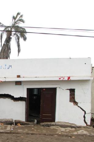
The amount of soil deformation following liquefaction depends on the looseness of the material, the thickness and areal extent of the liquefied layer, the ground slope, and the distribution of loads applied by buildings and other structures on the ground surface.
Determination Difficulties of Cyclic Strains of Soil During Earthquake
Estimation of the seismic response of shallow foundations during a strong earthquake has been proven a difficult task throughout the years. The main cause of this difficulty arises from the fact that soil behaves in a highly non-linear manner when subjected to large cyclic strains.
It can deform substantially and, when saturated, can develop high pore pressures and finally liquefy. Liquefaction consequently leads to severe loss of bearing capacity, which damages seriously the superstructure. Extensive damage to shallow foundations due to liquefaction has been reported in numerous cases in the past, from Niigata (1964) earthquake to the more recent 1999 M 7.4 Kocaeli earthquake.
It can deform substantially and, when saturated, can develop high pore pressures and finally liquefy. Liquefaction consequently leads to severe loss of bearing capacity, which damages seriously the superstructure. Extensive damage to shallow foundations due to liquefaction has been reported in numerous cases in the past, from Niigata (1964) earthquake to the more recent 1999 M 7.4 Kocaeli earthquake.
 Despite the severity of damages, relatively little has been achieved towards the development of a consistent methodology for the design of foundations systems under these circumstances. Usually, the presence of superstructure is neglected and calculations are performed for free-field conditions.
 |
| Liquefaction Impact |
 |
Kaptai Dam of Bangladesh
Kaptai dam is the one and only dam of Bangladesh that is used to generate hydro-electric power. This dam was constructed across Karnaphuli River at Kaptai in Rangamati district, 65 km upstream of Chittagong. It is an earthfill embankment dam which reservoir is called Kaptai Lake. The water storage capacity of the Kaptai dam is 11000 km2. The construction of the dam was started in 1957 and was completed in 1962.
Under the guidance of then Chief Engineer (Irrigation) Khwaja Azimuddin, the construction site was chosen at present location of the dam in 1951. The International Engineering Co. Inc. (IECO) was engaged for a study on the project. Utah International Inc. was selected as construction contractor.
 |
| The 16 gated (each 12.2 m X 11.3 m size) spillway of Kaptai Dam have discharge capacity of 625000 cusec. |
 |
| Kaptai Dam with spillway and Power Plant |
Kaptai dam can reduce the downstream flood peak in the Karnafuli river by 50% by storing water in the reservoir. Kaptai dam is 670.56m long and 45.7m high. The width at the foundation level is 45.7m and at crest level 7.6m. The crest level is 36m above mean sea level (MSL).
 |
| Beauty of Kaptai Lake |
India Have Got Third Position in Dam Building
Before independence i.e. 1947, there were fewer than 300 large dams in India and by the year 2000 the number had grown to over 4000, more than half of them built between 1971 and 1989. India is declared to be the third in the world in dam building, after US and China.
Dams in India have been built across many perennial rivers. These dams are a part of the several multi-purpose projects launched by India to serve a variety of needs. In a multi-purpose project, a river forms a unit and a river valley is developed, by exploiting all the resources of the river.
 |
| Durgapur Barrage across the Damodar River at Durgapur in Bardhaman district in the Indian state of West Bengal. |
Dams are built to harness the river water so that it can be utilised according to needs. A multipurpose project is launched often for storing water for irrigation purposes, generating hydro-electricity by utilising the water stored by the dams, preventing floods and facilitating afforestation in the catchment areas of the reservoirs. However, the dams also provide drinking water, using the canals for navigation in some areas and also facilitating pisciculture and recreational activities. The main multipurpose projects constituting the major Indian dams are the Hirakud Project in Orissa, the Bhakra Nangal inPunjab, the Damodar Valley Project in Bihar and Bengal, the Tungabhadra Project in Andhra Pradesh and Karnataka, the Rihand Project in Uttar Pradesh.
 |
| Hirakud Dam across the Mahanadi River, about 15 km from Sambalpur in the state of Orissa in India. |
Some of the Indian dams were built primarily for flood control, water supply, and hydroelectric power generation, the primary purpose of most Indian dams (96 percent) remains irrigation. In fact, large dam construction in India has been the main form of investment in irrigation undertaken by the Indian government. But, starting in the 1980s, public investment in large dams in India has been the subject of a sustained controversy that was epitomized by the Sardar Sarovar Project, based on the balance between the social, environmental, and economic costs of dams and their benefits.
 |
| Bhakra Nangal Dam is situated across the river Sutlej that falls under the region of Bilaspur in Himachal Pradesh |
Tourist Spot near Dams is very much popular and good sources for attracting tourists. There are all the states in India where dams have been established but Karnataka is very rich in having most of dams and Reservoirs. Dams in Karnataka is very popular serving the purpose of people of Karnataka and Bangalore. Karnataka is much enriched in terms Dams in South India.
1. Almatti Dam
|
2. Gajanur Dam
|
3. Gundal Reservoir
|
4. Harangi Dam
|
5. Hidkal Dam
|
6. Kadra Dam
|
7. Kanakanala Dam
|
8. Kanva reservoir
|
9. Kodasalli Dam
|
10. Krishna Raja Sagara Dam
|
11. Lakkavalli Dam
|
12. Linganamakki Dam
|
13. Marconahally Dam
|
14. Mari Kanive Dam
|
15. Narihalla Dam
|
16. Nugu Reservoir
|
17. Sathanur Dam
|
18. Supa Dam
|
19. Suvarnavathi Reservoir
|
20. Thippagondanahalli Reservoir
|
21. Tunga Anicut Dam
|
22. Tungabhadra Dam
|
23. Vani Vilas Sagar Reservoir
|
Subscribe to:
Posts (Atom)